Chart of Holmes Hole
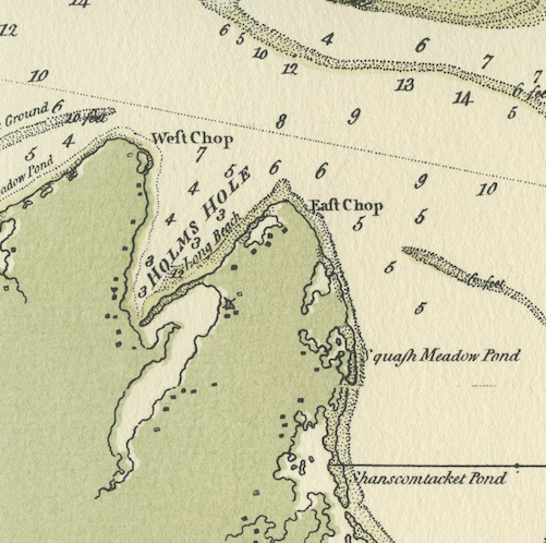
Chart of Holmes Hole
Lieutenant Joseph F. W. Des Barres (“de Bar”), an officer in the Royal Navy, mapped the coast of eastern North America during the American Revolution. His charts, issued in a multi-volume atlas called The American Neptune, remained the best available for nearly 75 years. Today, they are invaluable historical sources: detailed portraits of the Vineyard as it looked before the shoreline changes of the last 250 years.
This view of Holmes Hole (now Vineyard Haven) harbor in 1781 looks familiar at first glance, but a closer look reveals unfamiliar features. Point Pond, just inside the tip of West Chop, was once a refuge for small fishing boats. It disappeared shortly after 1900, when waves and currents erased the narrow strip of beach dividing it from the harbor. The opening that, spanned by a drawbridge, now connects Lagoon Pond with the harbor did not exist in Des Barres’ time. Instead, boats and small ships entered the Lagoon through Bass Creek: A broad channel, 6-7 feet deep, at the head of the harbor. It, too, is gone today: Water Street and Lagoon Pond Road follow the path it once took.
Des Barres’ chart shows the Middleground, a narrow shoal off the north shore of West Chop, lying about two feet below the surface–shallower than it is today. If it was even shallower earlier in the 1700s, and perhaps once an exposed Island, legends that Colonial-era farmers grazed their sheep there may be true.
DETAILS
| Artist | Joseph F. W. Des Barres for the Royal Navy |
|---|---|
| Title | Chart of Holmes Hole |
| Date | 1781 |
| Type | Document |
| Thematic Collection | 100 Years, 100 Stories: Building on Sand |